Press Release
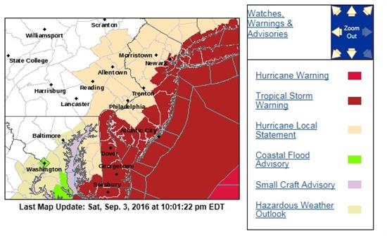
State of Emergency in EffectTropical Storm Hermine Set to Impact Jersey CoastIn anticipation of Tropical Storm Hermine, the National Weather Service (NWS) has issued public advisories warning of a dangerous storm surge along the New Jersey coast. According to the NWS, Hermine is expected to strengthen to Hurricane Force on Sunday, September 3, 2016 and impact the Jersey coastal waters for several days. A small craft advisory has been issued by the NWS through noon Weds., Sept. 7 through, and wave heights were estimated to be up to twice normal size as of Sept. 6. Below are links to resources that can help residents prepare and stay up-to-date on the storm’s latest developments (click on links or graphics for information): National Weather Service Forecast Office
National Weather Service/National Oceanic Atmospheric Agency (NOAA) sites on: Monmouth County Office of Emergency Management Ocean County Office of Emergency Management Mercer County Office of Emergency Management Jersey Central Power & Light (JCP&L): Report Power Outage (1-888-544-4877) Public Service Enterprise Group (PSEG): Report Power Outage (1-800-436-7734)
|